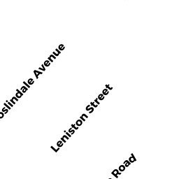
17 LENISTON ST
Owner Information
POTTER MICHAEL A
17 LENISTON ST
ROSLINDALE, MA 02131


Property Details
17 LENISTON ST is classified as a Single Family Residential (Colonial).
The primary structure on this property was built in 1920. There is 1,699ft2 of residential/living space within this property. This property is listed as having 8 rooms.
17 LENISTON ST is valued at $588,900. The land is valued at $161,000 and the structures are valued at $427,900.
The most recent deed for 17 LENISTON ST is recorded at the local registrar in Book 28364, Page 129. 17 LENISTON ST was last sold on Tuesday, April 16, 2002 for $318,200.
Assessment data from fiscal year 2020.
Flood Data
According to the FEMA National Flood Hazard Layer, this property does not appear to be in a flood zone. It may also be in an area not yet reviewed. Nonetheless, confirm this information prior to taking any action.
To view the flood hazards around this property, create a FEMA "Firmette" Map of the area around 17 LENISTON ST.
Broadband Internet Providers
| Provider | Type | Bandwidth (mbps) | |
|---|---|---|---|
| RCN | Cable | 500 | 20 |
| RCN | Cable | 1000 | 20 |
| VSAT Systems, LLC. | Satellite | 2 | 1 |
| GCI Communication Corp. | Satellite | 0 | 0 |
| Crown Castle Fiber | Fiber | 0 | 0 |
| Comcast | Cable | 1000 | 35 |
| Verizon New England Inc. | Fiber | 940 | 880 |
| HughesNet | Satellite | 25 | 3 |
| Verizon New England Inc. | DSL | 10 | 1 |
| Viasat Inc | Satellite | 100 | 3 |
Broadband service provider data from December 2020.
Adjacent Properties
- 15 LENISTON ST
Single Family Residential owned by SHERMAN-STOKES SARAH - 23 LENISTON ST
Single Family Residential owned by HILL JAMES - 230 ROSLINDALE AV
Single Family Residential owned by DEMERJIAN FAMILY TRUST - 226 ROSLINDALE AV
Three-Family Residential owned by HATZIPETROU PAUL - 222 ROSLINDALE AV
Apartments with Four to Eight Units owned by ACQUIRED CAPITAL PROPERTY